Android Wear version
Last updated Apr 2016
The Android Wear version of the app has five pages that you can swipe between as shown below:
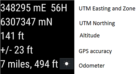
- The first page displays your location information including the UTM zone, easting/northing, lat/lon or MGRS coordinates, altitude, GPS accuracy, and speed/direction or odometer.
To reduce the brightness of the screen to save battery power press the brightness button. Press it again to restore brightness levels.
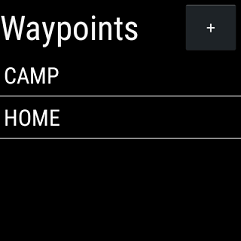
- The second page shows your recorded waypoints. Press a waypoint to view its properties.
The properties dialog shows you the coordinates and allows you to "goto" the waypoint or delete it.
Press the "+" button at the top to mark a new waypoint at your current location.
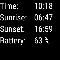
- The third page shows the current time, computed sunrise and sunset times, and the remaining battery power.
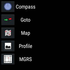
- The fourth page has buttons that allow you to bring up the compass, goto, map, and elevation profile pages, show your current MGRS grid reference, or manually enter a lat/lon waypoint.
The compass will only work if your watch has magnetic field and accelerometer sensors.
To calibrate the compass, move your watch in a figure-8 pattern in the air and/or rotate it on each 3D axis in turn.
To close most of these pages, swipe left to right. However, you need to use a long press to close the map page - this is so that panning the map does not accidentally close the page.
- The fifth page allows you to change the settings such as coordinate type and units (metres and kilometres per hour, feet and miles per hour, or nautical miles and knots).
You can also press a button to upload the waypoints to the HandyGPS folder your on phone if it is currently paired with your watch via BlueTooth and HandyGPS is also running on your phone.
The upload function creates a KML file named wear_waypoints_YYYY-MM-DD.kml, where YYYY-MM-DD is the the current date.
To download waypoints from the phone to the watch instead, use the download option on the main page menu of the phone app.
This allows you to choose a KML file from the HandyGPS folder on your phone to send to the watch. Currently you will need to restart the watch app to refresh the waypoint list after doing this.
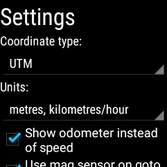
Note that to use the odometer feature, you should tick the "Show odometer instead of speed" option on the settings page. Leave the main coordinates page visible when using the odometer or recording a tracklog.
HandyGPS for Wear will work either when your smart watch is paired to an Android phone via BlueTooth, or stand-alone if the watch has its own GPS receiver. (Currently only the Sony Smartwatch 3 has a GPS).
All coordinates use the global standard datum, WGS84.
Before installing the app, make sure that your phone is paired to your smartwatch using Bluetooth and Google's Android Wear app is running.
Battery life: I have tested the app on a Sony Smartwatch 3 (SW3) and the app will run for a maximum of 4.5 hours with a full battery if the "dim" setting is selected on the main page of the app.
To get more battery life you can press the physical home button, which returns you to the watchface and allows the app to keep running in the background.
Using the app this way allows you to get up to 5.9 hours of use, depending on how often you bring the app back to the foreground. However, each watch and battery is different, so you should not rely on the these values. If in doubt, take an external battery bank to re-charge your watch.
I have recently added a new option to the settings page called "Power saving mode". This just checks the GPS location every 15 seconds instead of every second.
If I enable this option on my SW3 and re-start the app, for it to take effect, then I get about 6 hours of use in the dim mode, or about 11 hours in the background mode. To view the current location, I just need to re-launch the app (which is still running).
Note also that using the built-in GPS uses more power than using the GPS from your phone (via BlueTooth). Using the phone's GPS on the watch, I was able to get an estimated 16 hours of runnning of the watch app if I pressed the physical home button twice when not viewing the app (once to go back to home screen, twice to make sure backlight was turned off).
So, using the power saving mode, you should be able to run the app in the background all day while you're hiking even if you need to bring it to the foreground from time to time to record a waypoint or use it to navigate.
IMPORTANT: When you're finished using the app swipe to close it rather than pressing the physical home button since otherwise the app will continue running and waste battery power. If the app is still running, the GPS location
icon will be shown on the watchface.
A YouTube video about the similar HandyGPSWear app is available here.
Email:
Back to main page
BinaryEarth.net


The compass will only work if your watch has magnetic field and accelerometer sensors. To calibrate the compass, move your watch in a figure-8 pattern in the air and/or rotate it on each 3D axis in turn.
To close most of these pages, swipe left to right. However, you need to use a long press to close the map page - this is so that panning the map does not accidentally close the page.

You can also press a button to upload the waypoints to the HandyGPS folder your on phone if it is currently paired with your watch via BlueTooth and HandyGPS is also running on your phone. The upload function creates a KML file named wear_waypoints_YYYY-MM-DD.kml, where YYYY-MM-DD is the the current date.
To download waypoints from the phone to the watch instead, use the download option on the main page menu of the phone app. This allows you to choose a KML file from the HandyGPS folder on your phone to send to the watch. Currently you will need to restart the watch app to refresh the waypoint list after doing this.
