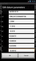
Handy GPS - Custom Datum Screen

This screen allows you to edit the parameters for the custom datum, which can be selected on the drop-down datum list on the main page of the app. This feature is only available in the full version of Handy GPS.
At the top is a button which allows you to choose from one of the pre-defined datums. If you choose one of these, the values below will be populated automatically.
However, if the datum you require is not in the list of predefined datums then you will need to manually enter the values, which you can find on various sources on the web.
Alternatively, a much simpler way is to purchase the CoordinateMaster app, browse to your desired coordinate system, and export a HandyGPS datum (.hgd) file.
The .hgd file can be copied from the CoordinateMaster folder into the HandyGPS/Datums folder, and then loaded into HandyGPS as a custom datum. Please note that HandyGPS only supports a subset of the systems which CoordinateMaster does since, for simplicity, HandyGPS only implements the lat/lon, transverse mercator and UTM projections. This means that it supports the majority, but not all, of the world's coordinate systems. You can view the complete list of systems that CoordinateMaster supports here.
Below the load and save datum buttons is a field where you can enter the name of the datum. This is only a reminder to yourself and can be any text you want, but try to keep it short since it is displayed on the datum chooser on the main page of the app.
The first two datum parameters are the ellipsoid semi-major axis (a), and inverse flattening (1/f)*.
The next seven parameters are the datum shift, or "toWGS84", parameters. If you only have three datum shift params (DX,DY,DZ), you can zero the remaining
four parameters and they will not be used. However if you have the full 7 parameters (DX,DY,DZ,RX,RY,RZ,S) then you can enter these and a more accurate
datum transformation will be performed. An abridged Molodensky transformation is used if only three parameters are provided, otherwise a Bursa-Wolf transform is used.
Following the datum parameters are a number of UTM projection parameters which may also be configured. These are the false easting (FE), false northing (FN), scale factor (k), latitude of origin, override longitude of origin, and longitude of origin. The normal values for the first three parameters for the northern hemisphere are FE=500000,FN=0,k=0.9996 and for the southern hemisphere are FE=500000,FN=10000000,k=0.9996.
The normal values for the other parameters are lat origin=0.0, override lon of origin = off, lon origin = 0.0. Note that if override lon of origin is off, the lon origin value is ignored.
The final value is the units factor. This is the value that when multiplied by the easting or northing, will convert them to metres. Normally this is set to 1.0, since Eastings and Northings are usually entered in and displayed in metres. But you can set this value to 0.3048006 if you want the Easting and Northing in feet instead.
Examples:
- SAD69 (South American 1969): a=6378160, 1/f=298.25, dx=-57.0, dy=1.0, dz=-41.0, FE=500000, FN=10000000, k=0.9996
- NAD83 (7-parameter transform, 2009 values): a=6378137, 1/f=298.257222101, dx=1.004, dy=-1.910, dz=-0.515, rx=0.02672, ry=0.00034, rz=0.01099, s=-0.0015, FE=500000, FN=0, k=0.9996
- ED50: a=6378388, 1/f=297, dx=-87, dy=-98, dz=-121, FE=500000, FN=0, k=0.9996
- British National Grid (OSGB36):: a=6377563.40, 1/f=299.325, dx=375, dy=-111, dz=431, FE=400000, FN=-100000, k=0.999601, lat origin = 49.0, override lon of origin = on, lon origin = -2.0
- Bogota Observatory (1975):: a=6378388, 1/f=297, dx=307, dy=304, dz=-318, FE=500000, FN=0, k=0.9996
- NZTM2000:: a=6378137, 1/f=298.257222, FE=1600000, FN=10000000, k=0.9996, lat origin = 0, override lon of origin=on, lon origin = 173
- Qatar National Grid: a=6378388, 1/f=297, dx=-119.425, dy=-303.659, dz=-11.0006, rx=-1.1643, ry=-0.174458, rz=-1.09626, s=3.65706, FE=200000, FN=300000, k=0.99999, lat origin = 24.45, override lon of origin = on, lon origin = 51.2166666667
- GDA 2020: a=6378137, 1/f=298.257222101, dx=-0.06511, dy=0.01087, dz=0.04019, rx=0.0394924, ry=0.0327221, rz=0.0328979, s=0.009994, FE=500000, FN=10000000, k=0.9996
Units
The customizable datum and projection parameters have the following units:
- a: metres
- 1/f: no units
- dx: metres
- dy: metres
- dz: metres
- rx: seconds
- ry: seconds
- rz: seconds
- s: parts per million
- FE: metres (usually 500000)
- FN: metres (usually 10000000 for southern and 0 for northern hemisphere)
- k: no units
- lat origin: degrees
- lon origin: degrees
*If you want to compute 1/f and you know the semi-major axis (a) and semi-minor axis (b) of the ellipsoid, the formula is 1/f = a/(a-b).
Note: HandyGPS uses the "coordinate frame rotation" convention for the rotation (rx,ry,rz) parameters.
This convention is commonly used in Australia and the US. But in Europe the "position vector rotation" convention is commonly used. The only difference between these conventions is that the signs of the three rotation values are reversed.
Back to main page
BinaryEarth.net
