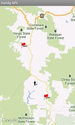
Handy GPS - Google map Screen

This screen lets you view Google map or satellite imagery overlayed with your waypoints and current location.
Waypoints are shown as red flags and your current location is indicated by a human figure.
The map can be panned by dragging a finger across the display and can be zoomed in and out using two finger "pinch" gestures, or double-tap.
There are also zoom-in and zoom-out buttons at the bottom of the map.
When you do a "long press" on the map, a dialog appears asking if you'd like to create a waypoint at that location.
In addition, pressing the menu button provides the option to centre on your current location,
switch between Google map and satellite imagery, to show or hide track logs, turn on/off the double-tap to create waypoint option, download OSM cycle map tiles for the current view,
and the ability to delete and/or export waypoints.
Back to main page
BinaryEarth.net
