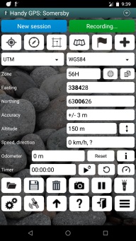
Handy GPS - Main Screen

At the very top of the page are two buttons: "New session" and "Paused" or "Recording". To start the app recording a tracklog, press the red "Paused" button and it will change to a green "Recording..." button. The session button allows you to start a new named session. This is optional and is described below.
Below this are 6 buttons whose functions are as follows:
- Turn on/off the GPS receiver
- Show the magnetic compass page (only available for phones which have a compass sensor)
- Show the current grid reference
- Show the map
- Show the waypoints list (selecting a waypoint shows a menu with options of "goto", "properties", "show on map", "rename", "edit", and "delete")
- Create a new waypoint using either your current location or manually enter coordinates
Below these buttons are two drop-down controls that let you choose the type of coordinates you want to view: UTM Easting/Northings, or lat/lons in various formats.
You can also choose the datum: AGD66, AGD84, GDA94, or WGS84. (GDA94, NAD83 and WGS84 are so close that they can be treated as identical by this app). The paid version also includes the option to use a custom datum which can be configured from the menu.
Next you can see the UTM zone (e.g. 56), and to the right of this is a "zone tool" button and a "copy" button. The zone tool button brings up a page which computes the zone number from a given longitude and vice-versa. This may be handy if you're manually entering waypoints and need to know what zone to use.
The copy button allows you to copy the current easting and northing to the clipboard. This may be handy for pasting your current location into Google Earth, an SMS or email message.
Below this are the Easting and Northing (or Latitude and Longitude) values.
Next are displayed the current GPS accuracy and altitude.
The button to the right of the altitude value allows you to view or edit the automatically computed geoid offset. This value is used to correct the raw GPS altitude value so it is more accurate for your current location.
Below this are your current speed and direction. If your speed is very slow, the direction will display a question mark, indicating that the direction of travel
cannot currently be computed.
Next is the odometere along with a button to reset it to zero.
To the right of the reset button is an info button which shows the number of currently loaded waypoints and track log points, along with other statitics.
Below the odometer is an optional timer line which is used to record the duration of your walk. This can be enabled from the preferences page.
At the bottom of the screen are another 12 icon buttons, in two rows, whose purposes are:
- Import
- Export
- Delete
- Take photo
- Pause/resume tracklog
- Flashlight
- Show the preferences page
- Show the GPS satellite status page
- Goto a waypoint
- Show the online help
- Exit the app
- Show the menu
Menu options
The main screen menu options are:
- Session: Starting a new session is an easy way to prepare the app for recording a new walk. It first asks if you want to export the currently loaded data, then lets you enter a session name for the area where you are walking (e.g. Somersby). Finally it deletes all currently loaded data and resets the odometer and timer.
Changing the session name simply changes the name of the current session name without deleting any data.
Session names are used to determine the default filename when exporting your walk data, and also for the name of the folder where photos taken from within the app are stored. The current date is automatically appended to the session name.
- Grid reference: Shows the simple 6, 8, or 10 digit grid ref or the MGRS grid ref, depending on what you have selected on the preferences page. If the selected custom datum name starts with "OSGB", then UK grid ref letter prefixes are also shown.
- Share location data: Provides options to share your current location or walk data via email or SMS.
- Browse photos: View the photos you have taken within the app during the current walk.
- Sun rise and sun set times: Once your current location is known, this computes the local sunrise and sunset times.
- Elevation Profile: View an elevation profile for the currently loaded track logs.
- Manage reference set: Allows you to import data from previous walks to use as a reference on the map during the current walk.
- Web based tracking: Allows you to share your current location with others in real time.
- Edit custom datum: Edit the parameters for the custom datum.
- Clear route: Clears the currently selected navigation route.
- Export to text file: Exports the current walk data to either a CSV or TXT file.
- Send current data to watch: If you have a paired Android Wear smartwatch, this sends the current data over Bluetooth to the Handy GPS app on your watch.
- Download file to watch: If you have a paired Android Wear smartwatch, this sends the selected KML file over Bluetooth to the Handy GPS app on your watch.
- Manage offline maps: This provides access to the same page that is available from the Maps page menu.
- GPS averaging: Compute a more accurate location over time.
- Show locations in all formats: Simultaneously shows the current location in UTM, Dec Deg, DMS, and DM formats using the WGS84 datum.
- About: Show the installed version of the app.
Back to main page
BinaryEarth.net
