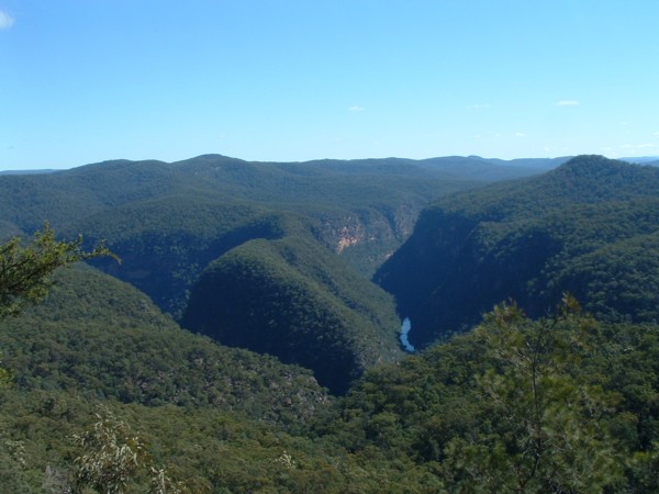
The Colo Gorge

Wollemi National Park, North-West of Sydney, NSW, Australia.


About this site


Walks to the Colo Gorge

WalkGrade(*)TimeDistanceAccess
Bob Turner's TrackEasy3 hours7 kmPutty Rd, Colo Heights
Mountain Lagoon (T3) TrackEasy4-5 hours5 kmSams Way, Mountain Lagoon
Colo-Meroo TrailEasy2 days23 kmSams Way, Mountain Lagoon
Canoe CreekMedium1 day5.5 kmGrassy Hill fire trail, off Putty Rd
Crawford's LookoutEasy3-4 hours8 kmCuloul Range fire trail, off Putty Rd
Crawford's Lookout to Boorai CreekMedium/Hard2 days20.5 kmCuloul Range fire trail, off Putty Rd
Drip Rock (Colo/Wollangambe junction)Hard2-3 days32.5 kmPutty Rd

See Discovering the Colo Wilderness on foot for track notes.

* The Colo Wilderness is rugged and remote. The gorge is surrounded in many places by impassable cliffs and walking along the river and side creeks is slow due to the boulders. The grades above are aimed at the level of an experienced bushwalker.


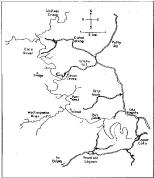
Click here for overview of Colo gorge (57 k)


Plants growing in the Colo Wilderness


Interesting fact: The word "colo" is an aboriginal variant of "koala". The explorer Francis Barralier mentions the word in his writings of 1802. He was attempting to find a way over the Blue Mountains at the time.


Colo River slide show


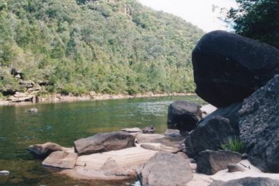
The river near Bob Turner's track - one of the only easy walks into the gorge.


All photos and text copyright Anthony Dunk 1997-2003.


Help keep the Colo beautiful

Anyone who's spent time in the Colo wilderness knows what an amazing and unspoilt area this is. So enjoy walking in this area, but practice minimum impact walking and camping. Make sure not to leave any rubbish, and if you've got the energy, carry an extra plastic bag and clean up any rubbish that you find lying around.


Environmental Concerns


The Wollemi Pines

A page with info about the Wollemi Pines can be found here. Also look out for James Woodford's excellent book on the discovery of these amazing trees.... a third stand of these trees has also now been discovered!

How many other biological treasures await discovery within 200 km of Sydney, by those suitably qualified to recognize them ?


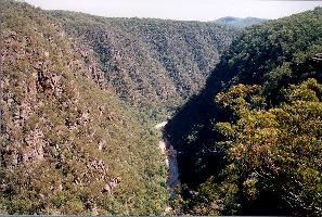
A view of the gorge from Culoul Range


Early explorers of the Colo

The first recorded white people to traverse the country north of the Colo River were Benjamin Singleton, William Parr, and John Howe in the early 1800's. In the 1830's Frederick D'Arcy was tasked with the difficult job of surveying this country. Blue Mountains historian Andy Macqueen's latest two books investigate the travels of these explorers.

In the 1880's a rough survey track was built along and, in places, above the Colo gorge by G. W. Townsend and his party. The plan was to survey an alternate railway route crossing the Blue Mountains which would avoid the tricky zig-zag railway line. The railway was never built and the old survey track is now barely discernable, being largely obscured by land slides and plant growth. A railway survey was also conducted along the Grose River at around the same time, resulting in the construction of the "Engineer's Track" there.


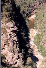
View of the Colo Gorge looking towards Mt Savage.


Aborigines in Wollemi

It seems that the rugged country around the Colo was a natural barrier between aboriginal tribal groups, but it was also a place where the different groups came together and shared their rock art. To the east were the Dharug and Darkingjung tribes, north the Kamilaroi and Wonarua, west the Wiradjuri, and south-west the Gundungurra.

During 2003, a team from the Australian Museum located and investigated a large number of aboriginal sites in the Colo Wilderness. One of the most significant is called "Eagles Reach". It is one of a number of rock art sites on a rugged plateau in a remote part of Wollemi National Park. The location of Eagles Reach is being withheld to avoid it being damaged. You can find an article about the art at the site here.

It may seem hard to believe that anyone could have ever lived in this rugged, scrubby country, but perhaps with regular burning by the aboriginals the country was much more open and productive than it is today. The bushfires of 2002/03 demonstrated this. Without them many of the recent discoveries probably wouldn't have been made. Fires however can also destroy rock art by heating the rock and making it crack.

Interestingly, some of the rock art around Gosford is remarkably similar to that at Eagles Reach, which is almost 100 km to the west. Compare this picture of a wallaby from a cave near Gosford with this one that the Australian Museum took at Eagles Reach.

I have put together a timeline of the recent rock art discoveries in Wollemi here if you want to know more.

Although its necessary to keep most aboriginal art sites secret to prevent them from being damaged it is a pity because many people are unaware of how many art sites are all around us, connecting us with a very ancient culture. I have seen literally hundreds of such sites in my bushwalks in the Sydney area, and that is just the tip of the iceberg of what is out there - much of it still unrecorded.


The background image on this page is some colourful windswept sandstone that I found in a cave on Culoul Range.


Where to find more information

Links


Feel free to email me or visit my home page.