 |
 |
The Macdonald River starts near Putty and joins the Hawkesbury River near Wiseman's Ferry. Much of its length is within Yengo National Park.
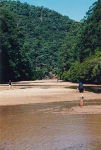
The Macdonald is a "river of sand". Its wide, sandy bed sometimes doesn't contain flowing water at all. Walking along the river bed is pleasant and peaceful, but the wet sand can be a little tiring because your feet sometimes sink.
One way the river can be reached is from Putty Road by driving to the end of the Wallaby Swamp 4WD trail (Map: Moruben 1:25000), and then walking for several hours through the bush. There is often no running water available in this rugged country so carry plenty of drinking water with you, or extract water from the bed of the river and boil it.
 |
Another possible access route to the Macdonald is Howes Range 4WD trail. This is a rough, and in some places, overgrown trail that leads from the Putty Rd to the trig station on Howes Range. The trail starts on the right just north of a cutting on Putty Rd. It is still some kilometres of rugged navigation from the trig station to the river.
On the other side of the river, Bala Range trail provides access. However, permission needs to be sought from the Central Coast NPWS before travelling along this trail.
The book "Bushwalks in the Sydney Region, Vol. 2" (National Parks Association) also contains a description of a walk which starts further upstream. This walk follows the bed of Howes Valley Creek, which is sandy and pleasant. [see Ref 1]
Putty Road crosses the Macdonald near Howes Valley which is about 74 kms north of Colo Heights. A track on the northern side of the bridge, on the right, leads down to the river. Here, the river flows through farmland for several kilometres before entering the National Park.
 |