The main AusDatumTool dialog has two areas: the input coordinates and the output coordinates. The drop-lists at the top of each allow you to select the datum of your input coordinates (e.g. AGD66) and the datum of the desired output coordinates (e.g. GDA94). You can also select the zone for the map you're working with (e.g. Zone 56 for eastern NSW). The zone is usually shown in the legend area of a printed map. If you choose to enter lat/lon coordinates, then the zone is automatically computed from the longitude when you press the "convert" or "refresh" buttons.
When you enter eastings and northings, remember to include all the digits (e.g 345700). The leading digits of the easting and northing are usually shown on topo maps in a smaller font. Note that the small boxes to the right of the Easting and Northing field display the two components of the 6-digit grid reference for the current easting and northing.
When you press the red arrow (convert) button, all the output coordinates will be computed from the input coordinates using the chosen datum and zone. The medium accuracy formulas from the Geodetic Datum of Australia Technical Manual are used for AGD66/84 and GDA94. These are accurate to about 1 metre. However, if the provided grid shift files (*.gsb) are present in the folder where AusDatumTool is being run from, then higher accuracy will be achieved using the NTv2 grid shift tables.
After performing a conversion you can press the button with the Google Earth icon on it to see this location in Google Earth, if its installed (WGS84, GDA94, GDA2020, and NZGD2000 datums only). You can also choose to save the Google Earth KML file using the "save" button below.
As well as interactive conversions, you can also batch convert a set of coordinates from a comma, pipe or space delimited file using the current conversion settings. Note that you must choose the correct coordinate systems for input and output in the main dialog before pressing the "Convert file..." button. You can also choose to output to a Google Earth KML file, but this will only be useful if the output coordinate system is set to GDA94, GDA2020, NZGD2000, or WGS84 Lat/Lon.
Below is an example of a comma delimited (CSV) file which this program accepts as input:
Easting,Northing,Description,Altitude
330000,6300000,"This is my first test point",100
330100,6300100,"This is my second test point",200
Note that for lat/lon input, decimal degrees, degrees minutes, and degrees minutes seconds formats are supported if first selected on the interactive page. For the later two formats, the components must be separated by spaces. e.g. -33 30 10.5
The Convert File dialog looks like this:

The "Topo map" button brings up a list of the Australian topographical maps which cover your entered coordinate. This feature is only available when the coord type is set to "Easting and Northing". All the Australian 1:25,000, 1:50,000, and 1:100,000 map sheets are supported. From this dialog, you can also press a button to view the map extents as a rectangle in Google Earth and/or export it to a KML file. (This feature uses data from www.anzlic.org.au).
If you have a map name and a 6-digit grid reference that you want to look up, then just press the "Topo map" button and select the "Choose my own map" option. This allows you to select the map series (e.g. 1:25,000) and then browse or search for the map name you want. You can then enter the grid ref at the bottom and press the "Use this grid ref" button to make this location your current coordinate in the main dialog. Finally you can click on the Google Earth button on the main dialog to show you where the location is.

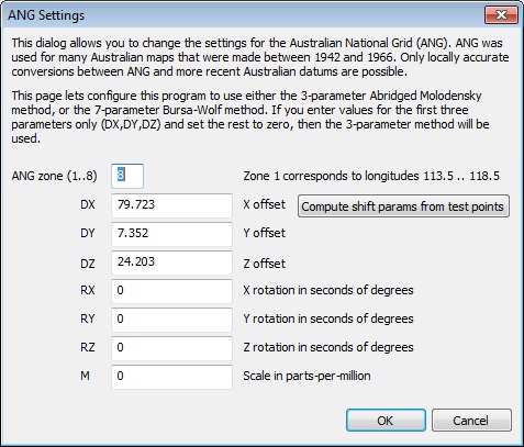
AusDatumTool also has support for pre-1966 Australian maps which use the ANG datum.
To use this you will need to first determine a set of at least 3 control points near your area of interest on the old
map sheet and then determine their location on modern maps. You will then need to determine the datum shift parameters and enter these into AusDatumTool using the button which appears next to the datum combo box when "ANG" is selected. You can compute these with either the in-built tool, which calculates a 3 parameter datum shift, or you can also use the ComputeDatumShift program to determine the full 7 parameters.

Datum shift parameters which give an accuracy of around 80 metres in the Gosford area.
You can find a step-by-step tutorial about this here.
Feedback via email is welcome.
Back to the AusDatumTool page...