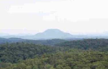
Profile of Mount Yengo seen from the Boree Track.
The basalt peak of Mount Yengo towers majestically, 300 metres higher than the surrounding sandstone country. Yengo is visible from the Putty Road as you descend the big hill about 18 kms north of Colo Heights (Culoul Range). Further north another peak, Mount Wareng, also draws the eye. Both these mountains are remnants of ancient lava flows which once covered the whole area.
To climb Mount Yengo, you currently need to seek permission from the owner of the property "Big Yengo" (call NPWS Gosford for contact details). Best access to this property is from Laguna along the Yengo Track (about 29kms of unsealed road). The top of Mt Yengo is quite overgrown but there are some grassy clearings on the edges of the mountain where you can get great views. The trig station marked on the topo map is difficult to locate in the thick scrub.
The aboriginal Wollombi tribe believed that Mount Yengo was a stepping stone used by Wa-boo-ee, the demon-spirit. Aborignal carvings at Burragurra (or Devils Rock) include spirit footprints.
|