Handy GPS Help
iOS version
Last updated Jun 2022

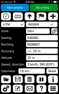
By default, the main page of Handy GPS shows your current location in UTM eastings and northings using the world-wide WGS84 datum. To start using the GPS press the red "Paused" button at the top-right. This will then change to the green "Recording" button shown above. Make sure you're outside where your phone has a clear view of the sky for best location accuracy.
You can use the drop-down lists near the top of the page to choose Lat/Lon coordinates and several datums including the common Australian datums. For the NAD83 (North American) datum, you can use WGS84 since this is almost identical. For other parts of the world you may need to configure a custom datum (see below).
Below these drop-down lists, the UTM zone is shown (e.g. 56H), along with the easting, northing, horizontal accuracy (e.g. +/- 10 m) and altitude.
If your GPS fix is accurate enough, and you are moving, then you will also see your speed and direction displayed.
Below this is an odometer which shows how far you've travelled since the "Reset" button was last pressed.
The main page has 5 buttons at the top. These bring up the compass page, map page, goto page, waypoints list, and allow you to add a new waypoint at your current location.

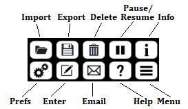
At the bottom of the page are another 10 buttons. The top row has buttons to import an existing KML or GPX file, export the currently loaded waypoints and tracklogs, delete waypoints and/or track logs, pause or resume receiving GPS location updates, and show information about the currently loaded data.
Note that importing data adds to the data already loaded rather than replacing it.
The next row allows you to change the preferences, manually enter the coordinates for a new waypoint, email your location to a friend, show these help pages, and show a menu of more options.

The preferences page allows you to select options such as metric or US/imperial units, and the track log recording interval. You can also enable a timer line which can be used to record how long your walk took.
The menu allows you to view the current grid reference in simple and MGRS formats, turn on the flashlight, edit the custom datum, enter a custom map URL,
view the computed sun rise and sun set time, view the elevation profile, email the currently loaded data, export waypoints to CSV, re-create the database, and view the app version info.
You normally won't need to use the "Re-create database" option, but it's there just in case the SQLite database which stores your data needs to be completely erased and re-created.
Saving battery power
GPS logging apps use more battery power than normal apps, so when you've finished using HandyGPS, bring up the task manager on your iPhone and close the app. For more info about saving battery power, please click here.
Click on a topic below for more info:
See also the Handy GPS FAQ and Handy GPS video.
Email:
Website: www.binaryearth.net


